The First Few Steps

“The Road goes ever on and on
Down from the door where it began.
Now far ahead the Road has gone,
And I must follow, if I can,
Pursuing it with eager feet,
Until it joins some larger way
Where many paths and errands meet.
And whither then? I cannot say”
J.R.R. Tolkien - The Fellowship of the Ring
Today marks the start of my attempt to cover all 870 miles of the Wales Coast Path. As I said in my introduction, this will be undertaken in bits and pieces over time. Despite that, I am going to be traditional and start at the beginning - at least the beginning from the perspective of someone who lives near Chester.

Trees in blossom from the Chester Walls
It is probably worth pointing out at this point that I am not an experienced walker. I have been doing it a long time, having mastered the basics over 50 years ago. However, I spend a lot more of my time sitting down. I have split the route into sections of roughly 10 miles or 16km. I judge walks in kilometres, not because I am mentally fully metric, but because 1km happens to be the distance I have to walk at work to get a latte. I am therefore used to short, reward-focussed walks. So going for extended walks where the availability of coffee is uncertain is well out of my comfort zone.
As my enthusiasm for this project does not run as far as doing it twice, I have to figure out the logistics of returning to my starting point. This resulted in my walk starting in the Chester Station car park. Not ideal, as this is not actually in Wales despite their best efforts in days gone by. So there was a 4k “pre-walk” to make my way across the city and along the Dee to the Welsh Border. There is little ceremony at the border, just a small sign and some marker stones. I was rummaging around in my big blue rucksack for some piece of photo gear when a passing walker asked me “Are you looking for your passport?” Top rambler humour there - I salute you, sir. The poor sign looks pretty beaten up - border towns have long memories.

Other walkers on the path were a rare sight, apart from those there primarily at the behest of their canine companions. What there was a lot of were cyclists and runners. The former were numerous because this part of the Wales Coast Path shares part of its route with a national cycle path. Even I have been known to MAMIL up and ride this way. The runners were numerous because there was some kind of club meet going on. It struck me what a wonderful multiplier of effort a bicycle is. I did feel a pang of jealousy as they whizzed past. Also occasional annoyance - bells guys, bells please! I never felt any jealousy of the runners though. Runners never look like they are enjoying what they were doing. I saw a dog who looked like he was enjoying it but none of the humans. There was one expressing joy, but that was only because he had finished.

Runners out training
The Dee at this point is often very straight due to being canalised. For Wales this is unusually “big sky country” as the path disappear into the distance and you walk on raised banks over reclaimed land. It seems to take a long time for the buildings on the horizon to get any nearer. As you pass the Saltney Ferry Bridge you see the Airbus Factory and Hawarden Airport and it is a reminder that this is still a working river. Giant A380 wings are loaded on to barges and sent downstream to Mostyn Docks for transport to France. I am not sure if the last wings have left yet given the cancellation of A380 production. Reminders of the industrial nature of this corner of Wales. Electricity pylons march across the landscape with you for most of the journey like titans.

The barge loading dock at Airbus

The Blue Bridge, Queensferry
The Blue or Jubilee Bridge at Queensferry marked the end of the part of the route I knew as I used to head up onto the Wirral on my cycle ride. I had to make a quick detour into the town in search of substance. Luckily I didn’t have to go too far before I found a Spar which sold butties and, even better, had a Costa machine.
I retraced my steps and left the paved roads behind for a bit. The river banks look suspiciously marshy but the path is still mostly raised up and there is a cycle path nearby if conditions are unfavourable.

Derelict building next to Hawarden Bridge
As you pass the Hawarden Bridge, the landscape starts to become far more industrial. The titans start to become a bit more numerous. Towering above them imperiously is the Flintshire Bridge. It’s central tower and asymmetric cables tend to catch the sun making it a landmark from some distance away. However, the sun was being very shy though on my walk and its hard to get a good view of it through the ranks of pylons.

This looks like it may be a pill box left over from WW2.
On reaching Connah’s Quay, a few more people started to share the path as the riverside is popular with anglers and dog walkers as well as families trying to burn off the Sunday roast. I chatted with the anglers and the gentleman in the hat had landed himself a couple of flounders.

There are reminders all along the quay of the maritime connections of this river port. There is also the only cafe I spotted along the direct route before getting to Flint.

In need of some restoration …

Path Marker
There is a tricky navigation spot here where the cycle path and WCP diverge but you need to go past the cycle path turn before the WCP sign is apparent. You soon learn to be on the watch out for the little Wales Coast Path roundels. They can be a bit small and discreet, especially compared to the cycle path signage. However, they do tend to come to your aid just as you are questioning your waypoints. I can recommend the Ordnance Survey app if you are prepared to subscribe. I planned my route at home and then could pick up my route through the app and download it. I wish I had put a little more effort in fitting my route to the path though as it does nag you you are off the route. I will probably do a separate post on route-planning and gear down the line once I have a bit more experience of how things are working out.
At this point the route turns into something of a slog. You leave the river and have to follow grab roads passed Coleg Cambria and then along the A548 coast road. You come to a major junction which gives you a close up view of the Connah’s Quay Power Station. Industrial it may be but you can’t help thinking that the designers had more than a little care for the aesthetic with it’s iconic quad towers and ranks of cooling chimneys.

Connah’s Quay Power Station

Flint welcomes you
There isn’t really a lot else to see along here and I felt distinctly conspicuous with my big blue rucksack with all its photographic accessories. I passed the sign for Flint but it seemed to take an age trudging along the road before Flint actually seemed to start. I couldn’t help feeling that someone walking the WCP in the opposite direction might find this leg a bit of an anti-climax. However, there was a twist int the tail. Just before you reach the town the path heads off the road and down to the estuary marshes. It was a bit squidgy underfoot in places but was teaming with wildlife. I finally got to breakout my new binoculars (they still had the ticket on them - what a newb!). I need to do some identification from my pictures and I will update the post but until then there were: egretty things (egrets), goosey things (Shelducks) and ducky things (Pintails) , wading things (Curlews and Oyster Catchers) along with the inevitable legions of gulls, pigeons and crows.

Looks like an egret to me though I don’t associate them with the UK.
It was was also about this time that the sun decided to make a more permanent appearance. The haze that had lingered all day still obscured the Wirral on the far bank but it was a pleasant change from the road section. The path loops you round until you reach Flint Castle and the lifeboat station. I took a few more picks till my first battery of the day died and then left the path to make my way to the station.
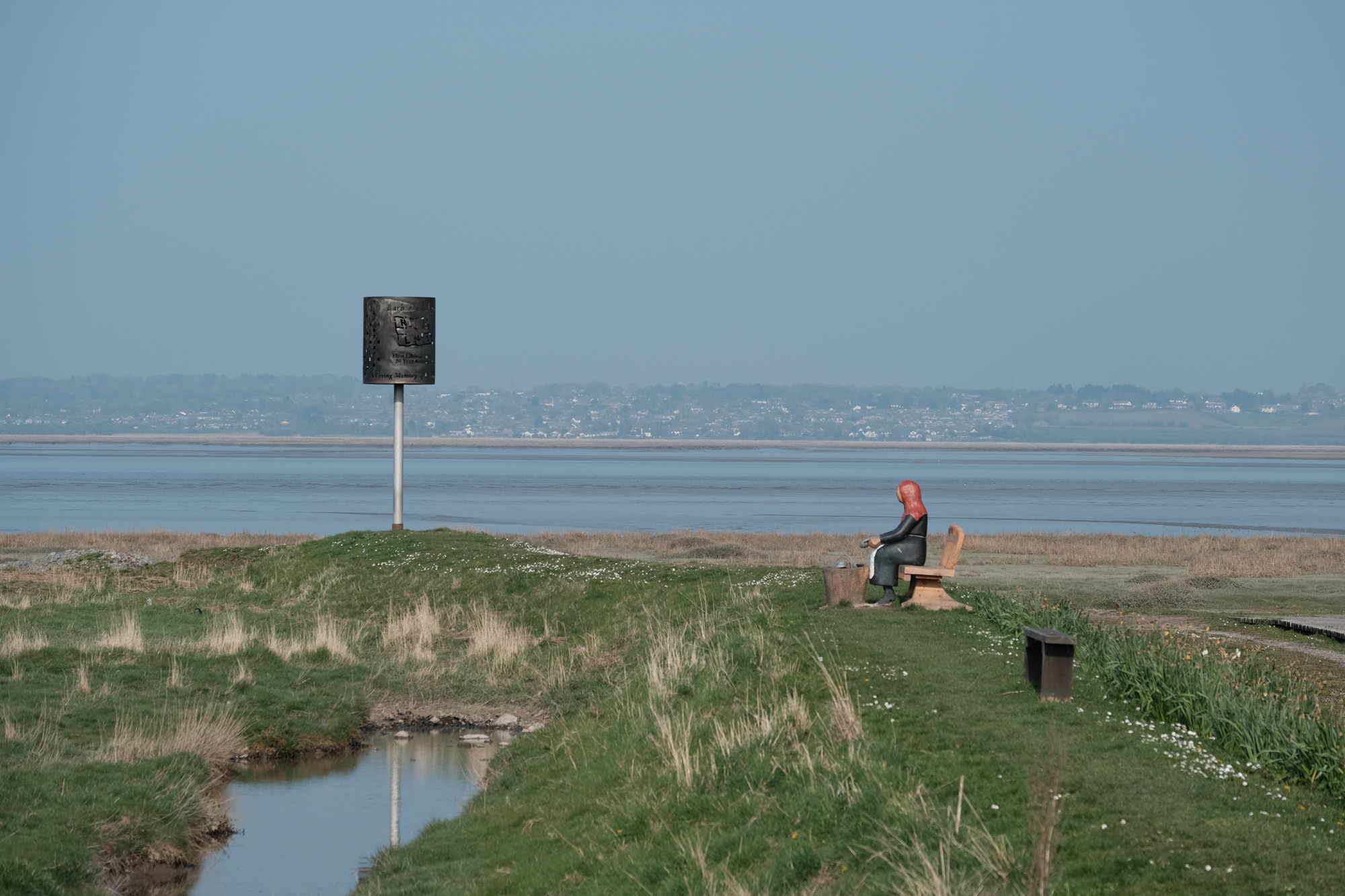
Lifeboat Sign and Statue looking towards the Wirral

Flint Castle
I got to rest my aching feet for half an hour in the sunshine until the train came. I did have this notion that I would sit by the window, grab some B roll video of the return trip or start downloading the pictures. However, I didn’t realise that Transport for Wales was a literal thing where the population of Wales just rides around on them the whole time. Standing, squished into the doorway like on a rush hour tube was not what my feet needed at that point - not in the slightest. Looking out of the small door window was weirdly like someone fast rewinding your life given that the path and the railway line are often so close. I even had to walk across it at one point on an unmanned crossing - eek.

It is slightly sobering that something that had taken me all day to walk had taken less than 20 minutes to retrace. It gives you an idea of how transformational the coming of rail transport was. My feet just thought it was 20 minutes too long!
Stats for the day
Total Distance covered: 25.6km
Planned WCP Distance: 16.2km